A Reply to John Daly's Recent Criticisms of the Port Arthur Sea Level Study
(See also an earlier discussion.)
John Daly (hereafter, JD) has questioned the use of the Tasmanian State
Datum in a journal article by Hunter et al., 2003. Here, these
criticisms are addressed and further corroboration is provided for the
use of the State Datum as an estimator of mean sea level at the end of
the 19th century. This reply is in six parts:
1. The significance of the State Datum to the conclusions
of Hunter, et al. (2003).
The State Datum, which was plotted on Figure 2 of Hunter, et al.
(2003), was only used to provide further weight to our belief that
the benchmark on the Isle of the Dead was originally located around
high water and not at mean sea level. We did not use the level of
the State Datum in any of our final results.
2. The nature of data archaeology and surveying.
Research involving data archaeology and surveying, by its
very nature, often involves data sources which are not as robust as
we would like. For example, we have to take much of the historic
data on trust because corroborative information does not exist; we also
often have to rely on secondary rather than primary (i.e. raw) data.
Furthermore, much of the levelling associated with studies of this type
involves survey marks which are defined by databases residing
in the local survey office (in this case, the Office of the Surveyor
General, Tasmania), with only brief (i.e. qualitative) details
of these marks being published (e.g. in the Tasmanian Government Gazette).
It is therefore difficult to exactly reference all survey marks used in
a scientific study; it is implicit that such data resides in the local
survey office.
3. The background of the Tasmanian State Datum.
Discussions prior to the adoption of the Tasmanian State
Datum indicated a requirement that it be related to mean sea
level (Government of Tasmania, 1941). The adoption of the
State Datum was prompted by the Survey Co-Ordination Act, 1944
(Government of Tasmania, 1945), and the Datum was related
to mean sea level by the definition
of a Reference Mark on the Hobart tide gauge building as
Permanent Survey Mark 1371 (Government of Tasmania, 1948). The
Tasmanian State Datum was the standard vertical datum
for Tasmania from the mid-1940s until the Australian Height Datum
(Tasmania) was defined in 1983. The height of this datum
and its relation to mean sea level is indicated in a number of
documents obtainable from the Office of the Surveyor General,
Tasmania, one of which specifies the period (1875-1905) over
which mean sea level was estimated (Government of Tasmania, 1946).
Therefore, over a period of nearly 40 years, the Office of
the Surveyor General had a clear understanding of the level of
the State Datum, and that it was related to mean sea
level. We agree that our statement that `in 1905, the Tasmanian
State Datum was defined, based on observations ..... for the
previous 30 years' was `shorthand' and not strictly
correct; although the State Datum was not adopted until after the Survey
Co-Ordination Act of 1944 (Government of Tasmania, 1945), that datum
had previously been used throughout the Hobart City Council region
(Government of Tasmania, 1941) and was apparently based on an estimate
of mean sea level for Hobart over the period 1875 to 1905.
4. The source of the data used to define the State Datum.
JD questions the source of the tide gauge data used to establish
mean sea level `over a period of 30 years previous to A.D. 1905'
(Government of Tasmania, 1946). Firstly, an automatic tide
gauge was installed in Hobart in 1889 and started recording on
1 December of that year (Marine Board of Hobart, 1894). Data from 1900 to
1907 is now missing, but it is evident that between 10 and 15 years
of data from the automatic tide gauge would have been available as a contribution to the estimation of mean sea level. There would also
have been other sources of tidal data prior to December 1889 (Mault (1889)
and a subsequent discussion attached to his paper indicates three examples),
and the existence of tidal observations was indicated on local drawings
(e.g. a map of proposed Hobart sewerage (Mault, 1886) and a plan of the storehouse at Port Arthur (Laing, about 1833)).
It also seems inconceivable that the development of the Port of
Hobart during the 19th century was not accompanied by tidal observations.
Although we do not have any original tidal data prior to 1889 that
may have contributed to the estimate of mean sea level used to
define the State Datum, the lesson is clear: people were observing
tides at Port Arthur and Hobart long before 1889. We have, therefore,
assumed that the data used for defining the State Datum was derived
partly from the automatic tide gauge established in 1889, and partly from earlier observations made, for example, on an ad hoc basis for
civil surveying purposes.
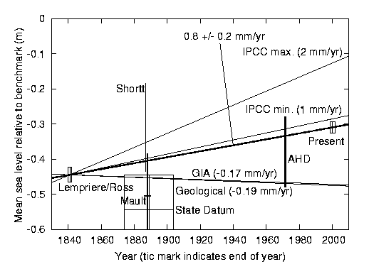
5. Our estimate of uncertainty in the State Datum.
JD questions our estimate of uncertainty in the level of the State Datum
shown in Figure 2 of Hunter et al. (2003), which we described as
being `dominated by a levelling error between Hobart and Port Arthur
of +/-0.1 m' (Hunter et al., 2003). In clarification, let us assume
that the uncertainty in the estimate
of Hobart mean sea level used for the definition of the State Datum is
almost certainly smaller than the uncertainty of our estimate of mean
sea level for Port Arthur for 1841-1842 (indicated by `Lempriere/Ross'
in the figure below, or in Figure 2 of Hunter et al. (2003)) which
is +/-0.021 m. When this level is transferred from Hobart to Port
Arthur, introducing a further uncertainty (due to levelling errors)
of +/-0.1 m, the total uncertainty does not significantly differ
from +/-0.1 m.
6. Is there corroboration for our belief that the State Datum
is a reasonable estimate of mean sea level?
Mault (1889) described the collection of 31 days of sea level data
in Hobart from 4 February to 6 March 1889 (i.e. prior to the installation
of the `permanent' gauge in late 1889). The mean tide level for
these observations was given as `35.255 feet below the datum mark on
the Town Hall'. This datum mark was also described as `fixed to one
of the steps of the Town Hall' and is almost certainly the same
mark as BM89, which is described by the Office of the Surveyor General as
on the `Town Hall steps' and 35.39 feet above State Datum. This
indicates that mean tide level (a good estimate of mean sea level
in this region where the shallow water tidal constituents are very
small) was 0.135 feet or 0.041 m above State Datum. We assume that
the uncertainty in this level is dominated by the environmental
variability of a 31-day average (+/- 0.056 m), using modern data from
nearby Spring Bay (Hunter et al., 2003). Mean tide level from
Mault's data is therefore 0.041 +/- 0.056 m above State Datum,
which does not significantly differ from the State Datum itself,
suggesting that the State Datum is indeed a good estimate of mean
sea level in 1889. When this level is transferred from Hobart to
Port Arthur, its uncertainty is again increased by an assumed
levelling error of +/-0.1 m, yielding a total uncertainty
of +/-0.12 m (rounding up, to be conservative). This estimate
is indicated by the bold cross annotated as Mault in the following figure,
which is based on Figure 2 of Hunter et al. (2003); the height of the cross provides an estimate of the uncertainty (+/- one standard deviation). For further explanation, see caption to Figure 2 of Hunter et al. (2003).
As noted in (1), above, we only used the State Datum to provide further weight
to our belief that the benchmark on the Isle of the Dead was originally located
around high water and not at mean sea level. Here we repeat paragraph 14
of Hunter et al. (2003), in which we have used a mean sea level
(and its associated uncertainty) from Mault (1889) rather than from
the State Datum (the values from Hunter et al. (2003) are bracketed in
red):
Statistical analysis of the data shown in the figure (Figure 2) reinforces
our belief that the benchmark was not located at mean sea level in 1841.
A least-squares fit of a linear trend to all the data shown, with due
regard to the a priori uncertainty estimates, yields a slope
that is not significantly different from the above trend (which was based
only on the 1841-1842 and the 1999-2002 data), and a high (69 (43)%)
`goodness-of-fit' probability. However, if it is assumed that mean sea
level in 1841 was at the benchmark, then the `goodness-of-fit' probability
becomes extremely low (0.13 (0.003)%), indicating that a constant
trend would not fit such data; any curve that does fit the data would
have to involve a steep fall (typically 9 (10) mm/year) prior to 1890,
followed by a rise of around 1 mm/year, which we believe to be physically
unrealistic.
In summary, we believe that there is no reason to doubt that the Tasmanian State
Datum is a reasonable estimate of mean sea level at the end of the 19th
century. However, if we ignore the State Datum as an indicator of mean sea
level and instead use the observations of Mault (1889), our conclusions are
not materially changed; in particular, our estimates of sea level rise based
on the Lempriere/Ross benchmark and on our modern tidal observations
remain identical.
References
- Government of Tasmania, Report and Proceedings of the Standing
Committee of the Co-Ordination and Correlation of Levels and Surveys in
Tasmania, 22 pp., Government of Tasmania, January 1941.
- Government of Tasmania, The Survey Co-Ordination Act, 1944, Tasmanian Government Gazette, 169, February 28, 1945.
- Government of Tasmania, Sheet showing State Permanent Marks entitled `Level Datum; The Survey Co-Ordination Act, 1944', dated `30.5.46', 1946.
- Government of Tasmania, The Survey Co-Ordination Act, 1944, Tasmania, Tasmanian Government Gazette, 2104, July 21, 1948.
- Hunter, J., R. Coleman and D. Pugh, 2003, The sea level at Port Arthur, Tasmania, from 1841 to the present, Geophysical Research Letters, 30, (7), 1401, doi:10.1029/2002GL016813, 2003.
- Laing, H., Plan Elevation & Sections of the storehouses now erecting at Port Arthur, PWD266/1828, Archives Office of Tasmania, Australia, about 1833.
- Marine Board of Hobart, Minute Book, Vol. 5, Meeting of 29 Nov. 1889, Record AB830, Archives Office of Tasmania, Australia, 1894.
- Mault, A., City of Hobart sketch plan showing proposed sewerage, Crowns Lands Department, Hobart, State Library of Tasmania, Tasmania Collection, July 1886.
- Mault, A., On some tide observations at Hobart during February and March, 1889, Papers and Proc. Roy. Soc. Tasmania, 8-12, 1889.
John Hunter, 7 October 2003